The following aerial photos of the tornado area in Joplin, Mo., taken by Newt Sharp of Joplin, have been released for use by ACM Newspapers.
Click image to view larger and drag to desktop to download. Please credit Newt Sharp.
 |
The area near the intersection of 20th Street and Connecticut Ave., in Joplin, Mo. Somerset apartment complex
is located in upper left-hand corner of photograph. / Photo by Newt Sharp |
 |
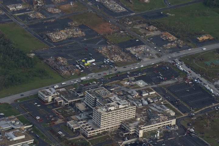
| The heavily-damaged St. John's Regional Medical Center. / Photo by Newt Sharp |
 |
| The EF5 tornado destroyed the Home Depot in Joplin, located along 20th Street. / Photo by Newt Sharp |
 |
| Medical Buildings near St. John's Regional Medical Center. / Photo by Newt Sharp |
 |
| Massive damage to an apartment complex located near the Walmart Supercenter, located on 15th Street and Range Line Road in Joplin. / Photo by Newt Sharp |
 |
| Severe damage to the Bel-Air Shopping Center, at the intersection of 20th Street and Range Line Road. / Photo by Newt Sharp. |
 |
| The tornado destroyed Irving Elementary School located in downtown Joplin. It was one of three Joplin School District buildings to be destroyed. / Photo by Newt Sharp |
 |
| The tornado destroyed Joplin High School, the only public high school serving the town of 50,000. The school was home to more than 2,000 students. The storm also destroyed Franklin Tech Center. / Photo by Newt Sharp |
 |
| The tornado damaged East Middle School, a new building in the district. East Middle School was located on the very eastern tip of the storm. / Photo by Newt Sharp |
 |
| The path of the storm can be seen in the middle of this photo. The photographer, Newt Sharp, is looking west over Joplin. The tornado's path stretches from Schifferdecker Road to the west to past Duquesne Road to the eastern edge of the city. |


No comments:
Post a Comment